Part 1: Climate
Latitude & Elevation
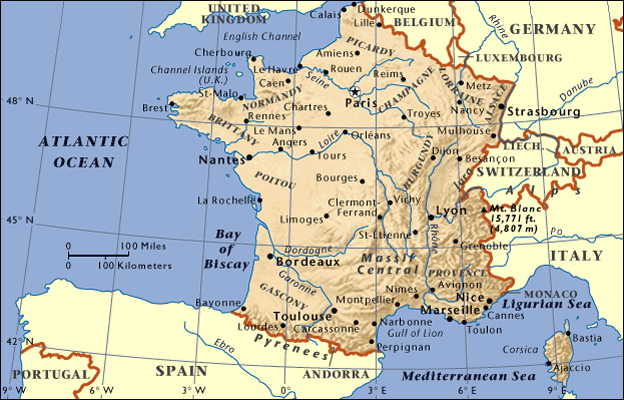
Metropolitan France is located mostly between the latitudes 41 degrees and 51 degrees N, and the longitudes 6° W and 10° E. The highest point in France (Mont Blanc) is at an elevation of 4,808 metres above sea level, while its lowest point rests 2 meters below in the Rhone River delta. France is home to a variety of elevations, from large, flat marshes to high and snowy mountains.
|

|
Temperature & Precipitation
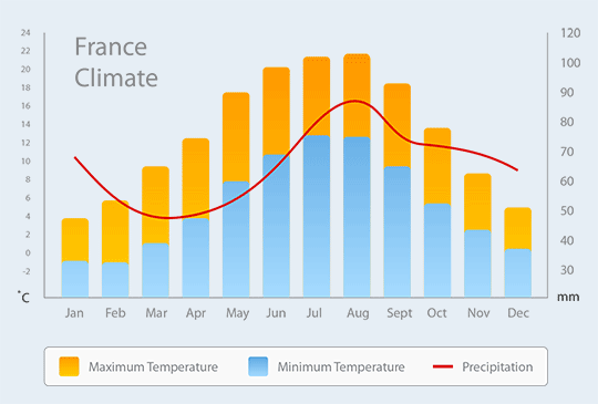
The north and northwest portions of France have a relatively temperate climate while influences from the nearby ocean, latitude, and altitude combine to create a varied climate for the rest of the country. Winters in France are quite cool, with the average temperature hovering around 6° Celsius (42.8° Fahrenheit.) Summers arrive in July and remain until about August, with the average temperature then being around a pleasant 25°C (77°F). The average annual temperature is hard to pinpoint as France experiences a wide variety of weather. It is easier to calculate the annual temperature of its capital city, Paris -- which comes out to a brisk 12.4°C (54.3°F). France receives around 25 inches of rain annually, experiencing the most of it in July and the least of it in January. Most of France is a Cfa or Cfb on the Köppen climate classification scale, though the French Alps have a high mountain climate (type EH).
